An Automatic Identification System (AIS) is a maritime communication technology that enables the automatic exchange of navigational information between ship-to-ship and shore stations, enhancing situational awareness and promoting safety at sea.
As the name says, you don’t have to call other ships to know more details about them. Just clicking the target’s icon on the ARPA or ECDIS will reveal all of their information such as the ship’s name, position, course, speed, and other relevant data.
As long as your ship has AIS transponder installed and they, too, have it, you can identify all ships navigating around you.
Additionally, nearby vessels, as well as coastal surveillance systems and satellites, will also know those details about your ship.
Key Takeaways
- An Automatic Identification System is mandatory on certain types of ships, according to SOLAS.
- Integrating AIS with other navigational tools like ARPA and ECDIS significantly improves its effectiveness.
- There are two types of AIS- Class A for SOLAS ships and Class B for non-SOLAS vessels.
- AIS transmits data such as ship identity, position, range, bearing, COG, cargo on board, ETA, etc.
What is the purpose of an AIS system?
Before this technology existed, navigators have to get the attention of the other vessel by mentioning its course and their bearing to each other. This wastes time and creates a great deal of confusion especially if there are many vessels in the vicinity.
But when the AIS was invented, ships can easily identify each other.
The primary usage of an Automatic Identification System is to improve the safety of navigation by satisfying the following functional requirements:
1. Efficient navigation of ships – ship-to-ship mode for collision avoidance.
2. Protection of the marine environment – a means for littoral States to obtain information about a ship and its cargo.
3. Operation of Vessel Traffic Services (VTS) – ship-to-shore traffic management.
Aside from these core functionalities, AIS offers some unintended benefits that further enhance maritime safety and efficiency:
- Enhanced situational awareness.
- Improved Search and Rescue (SAR) efficiency.
- Supporting maritime security.
- Efficient port operations.
- Aids to Navigation (AtoN), such as specific types of buoys.
- Increased transparency in maritime traffic.
- Data sharing and improved communication.
- Replaying ship’s movements especially during accidents like what happened with the container ship Dali.
Basic Working Principle of an Automatic Identification System
The basic working principle of an Automatic Identification System (AIS) involves transmitting and receiving VHF radio signals between vessels and shore stations to exchange essential information.
The key steps in the operation of AIS are as follows:
1. Data Transmission
Vessels equipped with AIS transponders continuously broadcast data packets containing information about the vessel, its position, course, speed, and other relevant details.
You can know more about the three types of data transmitted further down below of the post.
This data is transmitted at regular intervals on dedicated VHF channels.
2. Data Reception
Nearby vessels and shore stations equipped with AIS receivers pick up the transmitted AIS signals.
These receivers decode the information contained in the data packets to extract details about the transmitting vessel.
3. Data Processing
The received AIS data is processed to extract static information, dynamic information, and voyage-related information about the transmitting vessel.
This information is displayed on electronic navigation systems for operators to monitor.
4. Collision Avoidance
By receiving and processing AIS data from other vessels in the vicinity, the Officer of the Watch (OOW) can assess potential collision risks, monitor vessel movements, and take evasive actions to avoid accidents.
5. Situational Awareness
AIS data exchange enhances situational awareness by providing real-time information about vessel traffic.
This aids in navigation, traffic management, and coordination among vessels and maritime authorities.
Key Components of Onboard AIS Transponder
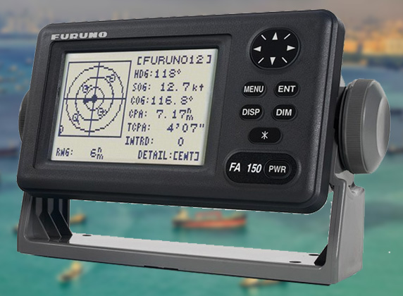
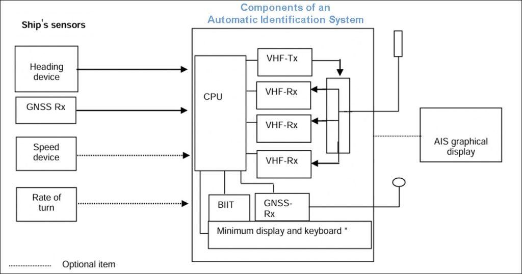
In general, a shipborne Automatic Identification System (AIS) consists of the following integral parts:
- antennas;
- one Very High Frequency (VHF) transmitter;
- monitor unit;
- two multi-channel VHF receivers;
- one channel 70 VHF receiver for channel management;
- a central processing unit (CPU);
- internal Global Positioning System (GPS) receiver;
- pilot plug.
Navigational Equipment Integrated into the AIS
The Automatic Identification System can operate as stand-alone equipment.
However, integrating it with other navigational tools significantly increases its effectiveness.
These are the bridge equipment and sensors connected to the AIS System.
- Electronic Chart Display and Information System (ECDIS).
- Voyage Data Recorder.
- Radar or Automatic Radar Plotting Aids (ARPA).
- External GPS.
- Heading Device (Gyro Compass).
- Speed Log.
- Rate of Turn Indicator.
AIS Carriage Requirements (SOLAS)
The International Convention for the Safety of Life at Sea (SOLAS) mandates specific carriage requirements for Automatic Identification Systems (AIS) on vessels.
These requirements are outlined in SOLAS Chapter V, Regulation 19. AIS is required for the following types of merchant vessels.
- All ships of 300 gross tonnage and upwards engaged on international voyages.
- Cargo ships of 500 gross tonnage and upwards are not engaged on international voyages.
- Passenger ships, irrespective of size.
Types of AIS Transponders
1. Class A
If you are sailing on merchant vessels on international voyages, your ship most probably has this type installed.
Class A transponders are mandatory for ships under SOLAS requirements listed above. These shipborne equipment complies with relevant IMO AIS carriage requirements.
Class A transponders are given priority for broadcast intervals.
The external GNSS (Global navigation satellite system), long-range function, and pilot plug connect to Class A AIS.
2. Class B
Class B devices may be carried on ships that are not subject to the SOLAS carriage requirements.
Their functionalities are not in full accordance with International Maritime Organization (IMO) AIS carriage requirements.
Lastly, they operate at a reduced reporting rate or when free time slots are available.
AIS categories based on data transmission
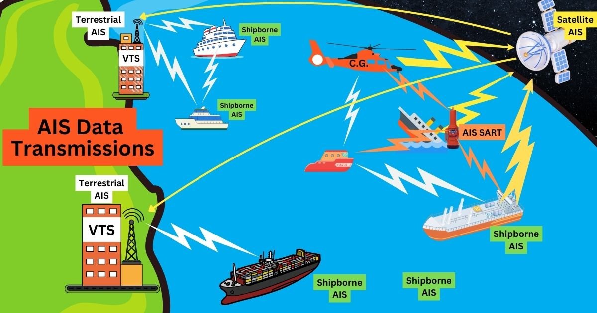
In addition to the two types of AIS classified under SOLAS and IMO regulations, the Automatic Identification Systems is also further categorized based on the method of receiving the AIS data transmissions.
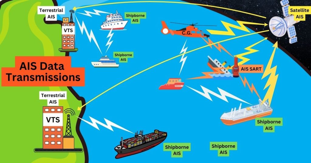
1. Ship-based AIS Transceivers
Ship-based AIS transceivers, also known simply as AIS transceivers, are onboard devices that facilitate the transmission and reception of Automatic Identification System (AIS) data.
Ships in range will show each other’s AIS information despite being outside the range of terrestrial AIS.
2. Terrestrial AIS (T-AIS)
Terrestrial AIS is a shore-based AIS installation that complements the shipborne AIS system.
They are the traditional method of receiving AIS data using coastal stations equipped with antennas.
Terrestrial AIS are installed in coastal areas to provide real-time vessel tracking and monitoring capabilities to maritime authorities and vessel operators operating in coastal regions.
Marine tracking websites usually show vessels that are in the range of terrestrial AIS.
3. Satellite AIS (S-AIS)
Satellite AIS utilizes satellites equipped with AIS receivers to detect and track AIS signals transmitted by vessels even in remote or oceanic regions where terrestrial AIS coverage may be limited or unavailable.
Just like the LRIT, they provide global coverage using satellite. However, the data transmission is sent directly to ground station instead of nearby ships.
Satellite AIS is usually commercialized. To monitor ships using satellite AIS, you have to subscribe to ship tracking sites online.
What data is transmitted by the AIS?
Ships transmit four different types of AIS information:
- Static information.
- Dynamic information.
- Voyage-related information.
- Safety-related information.
As the navigating officer, the second mate takes charge of updating some information in the AIS as part of the voyage planning.
Static information
Static information refers to the fixed data about a vessel that remains constant over time.
These data are transmitted or updated every six minutes or upon request.
- Maritime Mobile Service Identity (MMSI).
- Call sign and name.
- IMO Number.
- Length and beam.
- Type of ship.
- Location of electronic position fixing system (EPFS) antenna
Dynamic information
Refers to the real-time, continuously updated data about the current status and movement of a vessel.
The update rates are dependent on speed and course alteration.
- Ship’s position with accuracy indication and integrity status.
- Position Time stamp in UTC.
- Course over ground.
- Speed over ground.
- Heading.
- Navigational status (e.g., NUC, at anchor, etc. – manual input).
- CPA, TCPA, Range, and Bearing of other ships.
- Rate of turn (where available).
- Optional – Angle of heel (where available).
- Optional – Pitch and roll (where available).
Voyage-related information
Includes data that pertains to the specific voyage details of a vessel.
Update time is very 6 minutes, when the data has been amended, and upon request.
- Ship’s draught.
- Hazardous cargo (type).
- Destination and ETA.
- Route plan (waypoints).
Safety-related messages
This is like an instant messaging feature of the equipment used to send safety-related messages to other ships.
But we often use this to inform coast stations or other ships if we want to test our radio equipment as per GMDSS guidelines.
The update rate depends on the user, and the safety-related information may include:
- Collision avoidance messages.
- Navigation warnings.
- Weather updates.
- Manoeuvring intentions.
- Emergency alerts.
- Distress signals.
You might think this is similar to NavTex. However, NavTex provides more information and coverage and the option to print the message.
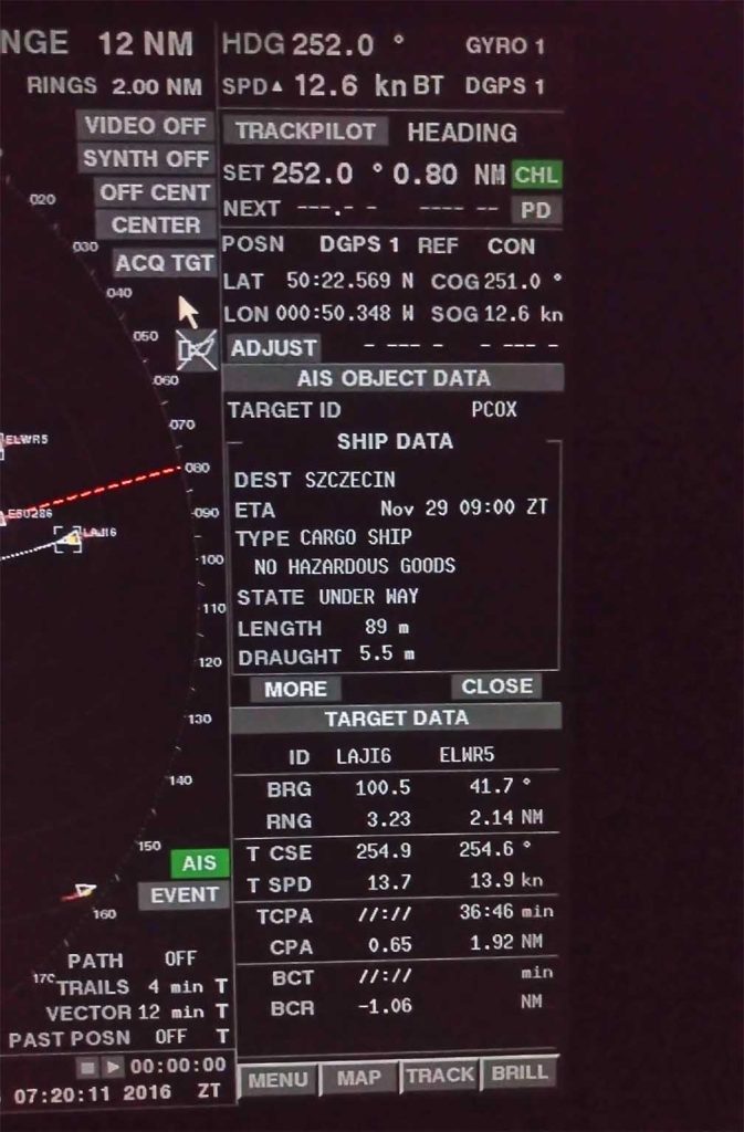
The integration of AIS data into ECDIS and ARPA greatly increased navigation safety.
Mariners are now more aware of their surroundings and they can even detect targets buried under sea or rain clutter.
Do you have questions regarding the Automatic Identification System? Drop them in the comments section.
May the winds be in your favor.

0 Comments