We’ve made a full circle! Our marine navigation has evolved quite a lot during the past years and now, we’re back to the skies.
Imagine yourself waking up in a little boat in the middle of the sea. You have no sight of land but the endless horizon around you.
No buoys, no mountain tops, and even no other ships around. Worse, you don’t even know where you are.
This was the life of a seafarer except, of course, we now know where we are and where we’re going. We use various navigation techniques, specifically called marine navigation, to find our way at sea.
During the time of wooden ships, our ancestors crossed the oceans with the help of the stars. Then we used crude methods when the skies were cloudy.
After many years, we invented LORAN which uses radio waves generated from land-based radio stations.
With the development of GPS, that method became obsolete too!
So from the stars to radio stations, to the global positioning system, our technology has evolved and continues to improve.
Even so, our types of marine navigation, or the way we navigate the ship, still remain the same. Whether you are sailing with a small yacht or a huge oil tanker, the fundamentals still remain the same.
Let’s discuss them here.
What is Marine Navigation?
Marine navigation is the process or way of directing the movement of a ship from one place to another via the shortest, safest, and most convenient route.
Take note of the last three criteria- shortest, safest, and most convenient route.
The bridge team, headed by the Captain, must harmonize these elements and put safety as the priority.
Marine navigation determines the vessel’s position at sea while plotting the course for the desired destination.
To do this, navigators employ different methods to find their way into the vast oceans.
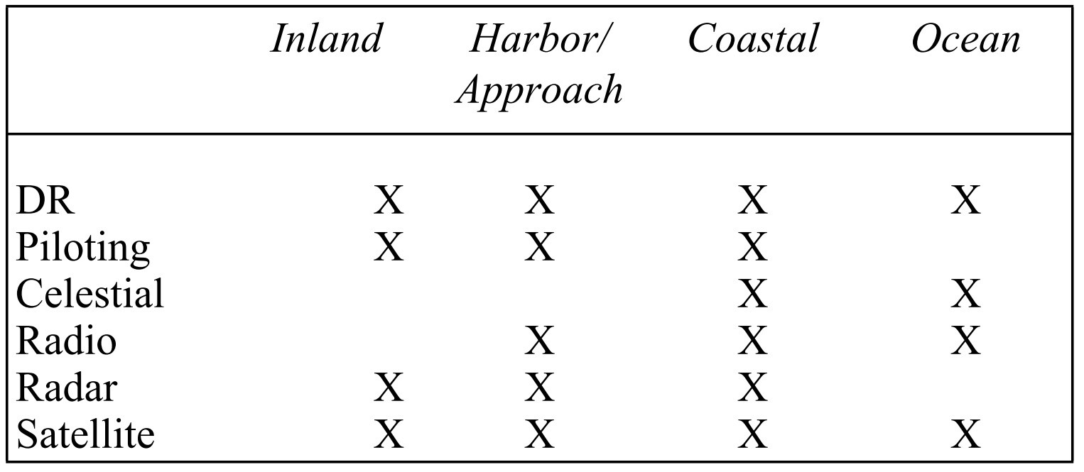
Types of Marine Navigation
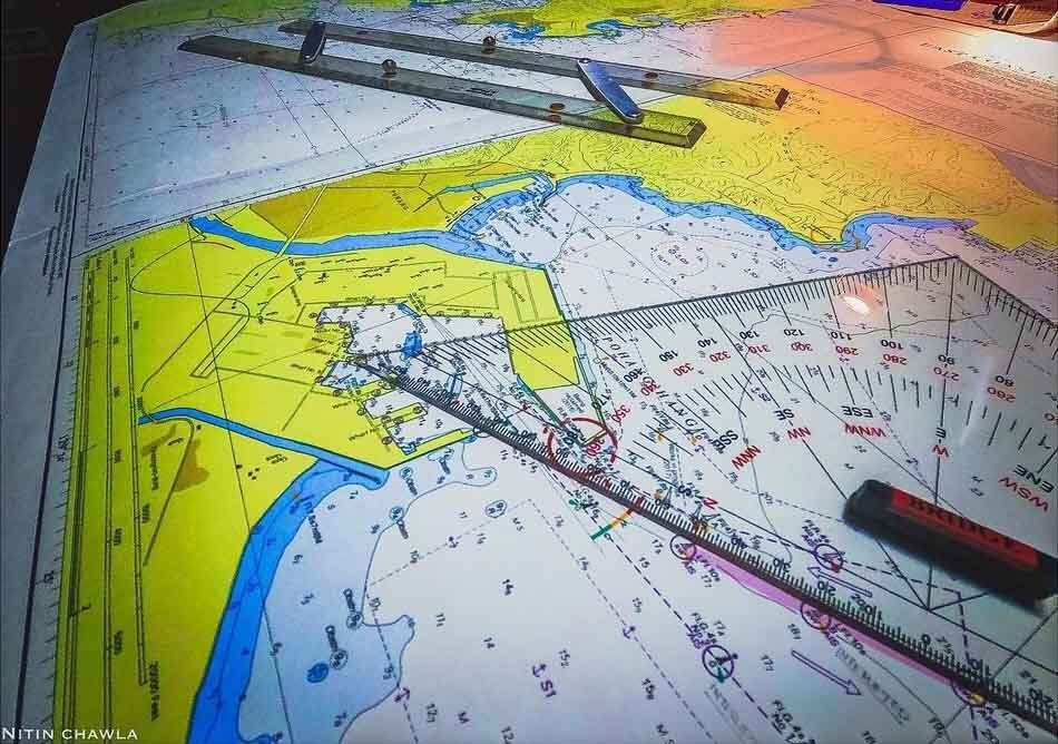
1. Terrestrial Navigation
The oldest form of navigation happened on inland waterways and near the coasts when people started to use them for exploration and transport.
As they frequent their routes and add more paths over time, they also discover hazards and dangers that could destroy their boats.
Thus, they started marking them with buoys like what we do today.
They also established terrestrial features that determine a simple maneuver to be made or as a position-fixing aid.
For example, when a ship passes a lighthouse on her port side and a promontory dead ahead of her, it’s time to turn to starboard. Earlier or later turns might be dangerous for the vessel.
Thus, they must meet these conditions before executing the maneuver to be safe.
These are the earliest forms of terrestrial navigation.
What is Terrestrial Navigation?
From the Latin word “terra” which means land, terrestrial navigation is a type of marine navigation that uses certain features on land to establish one’s position.
These landmarks could be naturally made like a high mountain, the promontory of land, capes, or even river deltas.
It could also be man-made structures like a lighthouse, buoys, the middle of a bridge, a breakwater, and similar objects.
In coastal waters, navigators fix the ship’s position using two ranges of terrestrial landmarks.

They use the most basic and widely available method of visual navigation called cross-bearing.
Take a bearing of two or three conspicuous objects and the point where they intersect is the ship’s position.
Piloting, channeling, canal, and river passage are areas where seafarers heavily use terrestrial navigation using visual or radar.
2. Celestial Navigation
Another form of marine navigation that followed the terrestrial method is celestial navigation.
As civilization grew and people made bigger ships to explore the unknowns of the vast oceans, they were out of range of terrestrial sights.
The only way to establish their position is to look up using certain tools. This is when celestial navigation was born.
What is Celestial Navigation
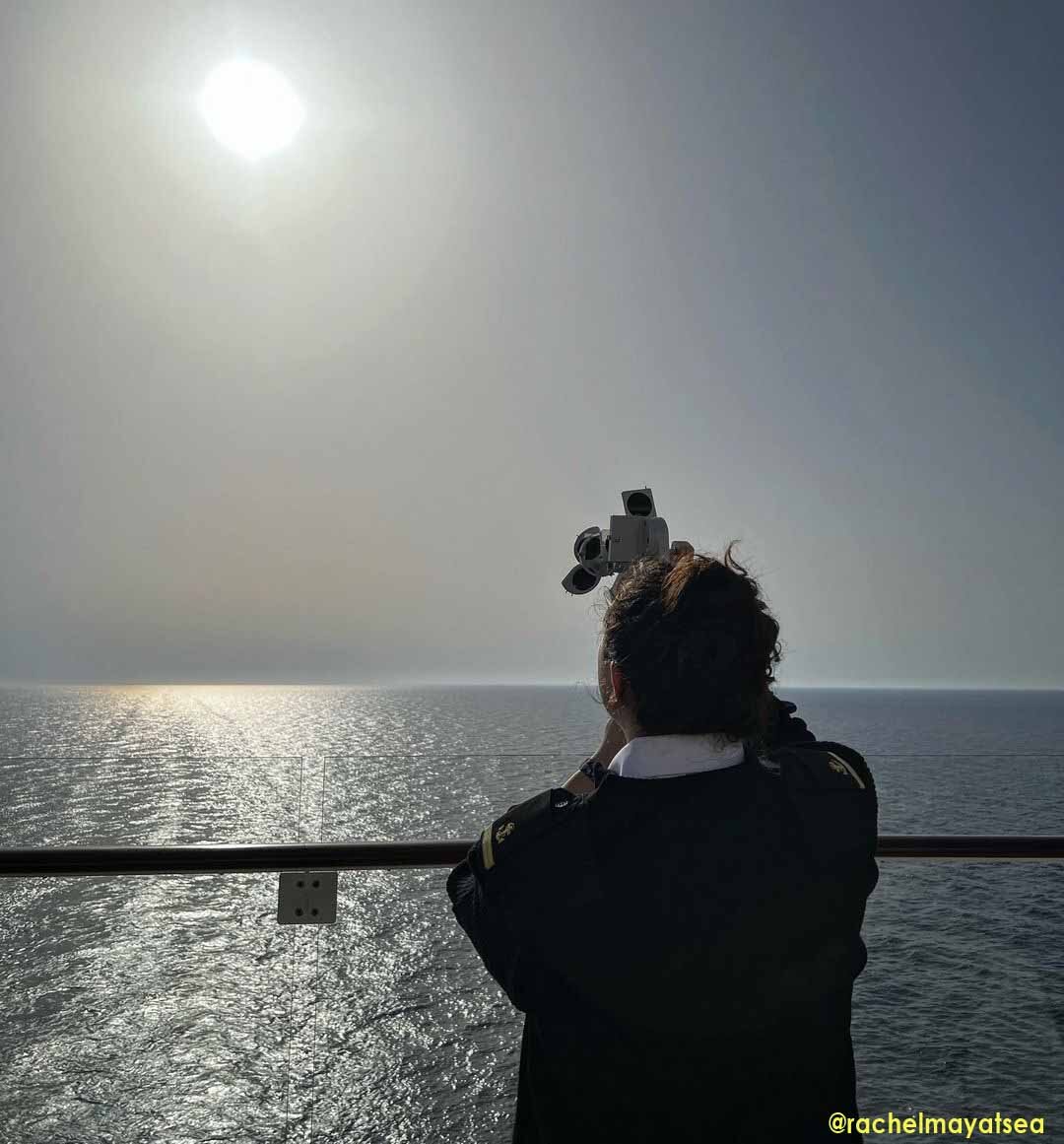
Celestial navigation uses celestial objects such as the sun, moon, stars, and other planets to determine the ship’s position.
Mariners take celestial observations using their favorite tool- the marine sextant. They turn their measurements into lines of position in a nautical chart using calculators, tables, almanacs, and spherical trigonometry.
Positions obtained from celestial navigation have made marks in history. This is how Magellan discovered the Philippines and Columbus reached the New World.
Together with terrestrial navigation, celestial navigation or CelNav was one of the most common subjects taught in our maritime school during our college days.
3. Dead-reckoning Method
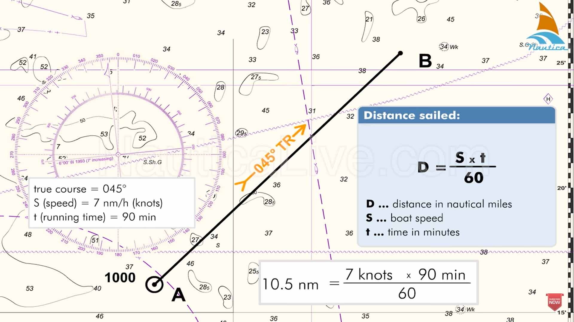
Another method for position fixing that goes hand in hand with celestial navigation is using DR or the dead-reckoning position method.
A dead-reckoning method is a type of navigation where the ship’s position is obtained using only four elements.
These are the ship’s latest known position, her course, speed, and time of the next position fixing.
Just in case you can not make a celestial observation during cloudy skies, your second-best choice is the Dead-reckoning position.
How to Use the DR Method
To get your DR position, refer to the latest known position and plot the ship’s course to it. Calculate the distance traveled from your known position to the time of the next position using the ship’s speed.
Since you have the ship’s speed (S) and time (T) interval, you should be able to get the distance (D) using the formula D=S x T.
Project the distance from your latest known position on your present course. That point is your dead-reckoning position.
However, DR excludes the effects of wind, current, and steering errors. If you apply them in your dead-reckoning position, it will now become your Estimated Position (EP).
When I was still a deck cadet, I made a lot of DR, EP, and LOP fixes, some of which are pot on the GPS position.
4. Electronic Navigation
The development of radios and antennas gave birth to electronic navigation that we now heavily use.
Ships can fix their positions quickly and easily using these electronic methods.
Whether on the nearest coast to the middle of the ocean, electronic navigation has proven itself useful and reliable.
What is Electronic Navigation
Electronic navigation is a type of marine navigation that uses radio time signals to determine the ship’s position anywhere in the seas.
These signals are transmitted and received using computers and gadgets integrated into each other.
This arrangement streamlines the data collection, processing, and analysis of various inputs.
The data is then flashed onto the screen or printed on a piece of paper so seafarers can use it.
The good thing about electronic navigation is that they are interactive, especially on electronic chart systems or ENCs.
Electronic navigation can be divided further into three kinds namely, Radio Navigation, Radar Navigation, and Satellite Navigation.
Radio Navigation
Radio navigation uses radio waves transmitted from radio ground beacons or broadcast stations.
These signals travel through the earth’s atmosphere until they reach the ship’s receiver radio. The signal is then processed to determine the ship’s position.
Hyperbolic systems like Decca, LORAN, and LORAN C were widely used during the early days.
Radar Navigation
Radar navigation is mostly used in coastal waters since it relies on fixed objects as a source of reference for position fixing. The radar transmits electromagnetic waves that get reflected back once it hits an object.
These targets appear on the radar screen and we can use them to get the ship’s position.
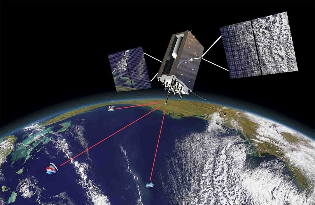
Satellite Navigation
Previously used in the military, satellite navigation is now widely adopted in the maritime sector.
Ships nowadays rely on this type of navigation as a major component of their marine navigation systems.
Satellite navigation uses geostationary satellites that orbit the Earth. Since satellites are high up in space, the receivers, which are vessels, are within their line of sight. This is important for position fixing.
They transmit radio signals and the ship’s GPS receivers calculate them based on their distance and time differentials. The resulting computation gives the ship’s latitude and longitude.
Though we have many types of marine navigation today, it is still wise to know the basics and their limitations.
Electronic navigation may be easier to use but since this is fully electronic, it is also prone to errors. Once these gadgets malfunction in the middle of the sea, they may be as unreliable as a brick.
Hence, many seafarers still practice celestial navigation as a backup.
May the winds be in your favor.
A family man, he loves writing, reading, investing, and watching the golden hours while sailing.
Please gyro compass next Sir.
Here is my article about gyro compass:
What is a Gyro Compass? Parts, How it Works, Limitations